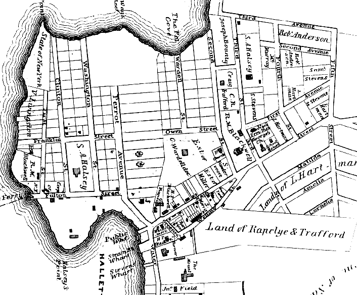
 HALLETS COVE, Astoria, Queens, N.Y., 1840
A section from Map of the Villages of Astoria (Late Hallet's Cove) & Ravenswood, Long Island, 1840
Source map at Queens Central Library, Long Island Division

Some street name changes between 1840 and today (old to new)
East-West
Franklin St. -> 27 Ave.
Owen St. -> Franklin St. -> 27 Ave.
Fulton St. -> Astoria Blvd.
*3 Ave. -> Linden St. -> Hoyt -> Astoria Pk. So.
*2 Ave. -> N. Washington Pl. -> 25 Road
*1 Ave. -> N. William -> 26 Road
Main St. -> Main Ave.
Welling St. -> St. Georges Pl. -> Welling Ct.
Based only on the maps I have, it appears that
Matilda, Amelia and Cornelia, were eliminated and
in that area (though, not in their exact locations)
Madison (1873), and later Clark (28 av) and Taylor (29 av) were established.
|
North-South
1 St. -> **Front St.? -> Mills St. -> 1 St.
Clinton St. -> Monson St -> 2 St.
Washington St. -> Halsey St. -> 3 St.
Perrot Ave. -> Boulevard -> Vernon Blvd.
Wardell St. -> 9 St.
2 St. -> Remsen St. -> 12 St.
3 St. -> Woolsey St. -> 14 St.
4 St. -> Willow St. -> 18 St.
5 St. -> Emerald St. -> Van Alst -> 21 St.
Greenoak -> Welling Ct.
Water St. -> Sunswick Terr. -> Boulevard -> Vernon Blvd.
|
* As early as 1850, the street names 1st, 2nd and 3rd Avenue were used elsewhere in Astoria.
See
1873 map and
1890 map for their location.
** Front Street appears in the 1864 Astoria directory as crossing Fulton and meeting the ferry.
I can't find it any of my maps, but by process of elimination, I believe it was 1st Street, as shown here.
Please contact me if you know better.
Also see these pages on
Old Astoria
and the
Astoria ferry
street name changes
Sep 2001
http://www.pefagan.com/gen/queens/qmp_hal1840.htm
|
|