|
County, Parish, Townland maps for Cavan Co., Castlerahan
|
|
|
|
 These three maps show a simplified
relationship of the subdivisions in Ireland,
but they give you a feel for scale and location.
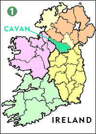
MAP 1
shows Ireland's 32 counties within
its 4 provinces.
County Cavan (bright green),
is within the northern province of ULSTER.
Cavan, along with Monaghan and Donegal (pale yellow)
were part of Northern Ireland (orange) until the 1920s,
when they joined the Republic of Ireland.
The other provinces are CONNAUGHT (pink),
MUNSTER (pale green) and LEINSTER (yellow)
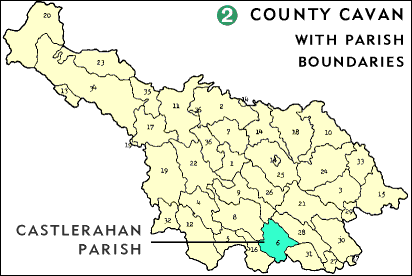
 MAP 2
is a blowup of the highlight from MAP 1.
It shows County Cavan's civil parish subdivisions
with Castlerahan highlighted.
The adjoining parish of Kilbride extends into County Meath
|
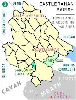
 MAP 3
is a blowup of the parish of Castlerahan,
subdivided by townland boundaries.
- Townland Barconey Grattan is highlighted in dark green.
Barconey Grattan is a triangular plot, defined in 1871 as 44 acres.
Its longest border follows a curved stream,
is roughly a half a mile in length and
is intersected by an east-west road that
climbs Mount Prospect.
The shortest border is about a quarter mile.
(these estimated lengths taken from
Ordnance Survey Map - 1:126,720 series #13, Meath)
- The Townland of Garyross (light green).
See overview below for connection.
- The red dots correspond with
- The town of Ballyjamesduff
- Castlerahan Catholic Church
- The town of Oldcastle, County Meath, Oldcastle Parish
- The rough boundaries of the parishes adjoining Castlerahan
within both County Cavan and County Meath are sketched in.
Note that the parish of Kilbride extends across
the county boundary.
BACKGROUND
Irish genealogical records are organized by one (or more) of
six key divisions: county, barony, civil parish, diocese,
poor law union and probate district.
Since many of these domains were established without regard
to other existing domains,
record retrieval is easier if you can pinpoint your
ancestor's place of origin.
- Townland = Barconey Grattan.
At the heart of the system is the Townland,
which was the smallest unit of addressing.
Today townlands appear only on historical maps,
but they are vital for location of records.
View a table and map
identifying the townlands
surrounding Barconey Grattan, and their
jurisdictions.
Barconey ("Barr Connaidh" in Irish)
is literally "Hill-top of Firewood."
Grattan is the name of a prominent family who owned
an estate in the nearby townland of Garyross
(highlighted in light green on MAP 3).
In 1854, a Henry Grattan owned all of Barconey Grattan
From "Silver Jubilee of the Official Opening & Solemn
Dedication of St. Joseph's Church,
Ballyjamesduff Co. Cavan"
quote provided by Michael Conaty
"Three or four generations of the Grattan Family owned an estate in
Garyross townland. The estate came to the family with the marriage of Dr.
Patrick Grattan of Trinity College to a daughter of the landlord of the
Garyross estate, Brereton.
In 1766 the Garyross property passed to the famous
orator and statesman, Henry Grattan, who is remembered for his opposition to
the Act of Union and his demand for Catholic emancipation. His younger son,
Henry as landlord of Garyross and other townlands in the county, took active
part in teh{sic} general election campaign of 1826. It was during that
campaign that Daniel O'Connell paid a visit to the county. Dean Jonathan Swift
was a friend of the Grattan family. The friendship originated in the home of
the literary Dr. Thomas Sheridan of nearby Quilca."
|
Town or village = Ballyjamesduff
("Baile Séamuis Duibh" in Irish) is literally
"Black James' Town"
Today, it is a small village (1991 pop. 829) at a crossroads.
It resides within the borders of two townlands:
Moodoge and Cornahilt, and on Oldcastle Street, Ballyjamesduff
is located one of the two Catholic Churches in Castlerahan.
The other is in Cormeen.
Ballyjamesduff was the winner of the 1967 "Tidy Town" award.
Parish - both civil and Catholic = Castlerahan, a.k.a.
Castlerahan and Munterconnaught, also spelled Castleraghan
Castlerahan is Caisleán Ráthain in Irish - literally
"Castle of the little rath".
[rath:
"An enclosure (usually circular in form) made by a strong earthen wall
and serving as a fort and place of residence for the chief of a tribe -
a hill fort" - OED]
County = Cavan
|
Finally, because they might be helpful in locating records,
I'll mention a few overlapping domains:
- The parish of Castlerahan is also part of the probate
district of Cavan and the Poor Law Union of Oldcastle.
And, as you can see on MAP 3, the town of Oldcastle
is in County Meath
- The parish of Castlerahan is also in the diocese of Kilmore,
which comprises 36 parishes: most of Co. Cavan as well as parishes
in North Co. Leitrim, Fermanagh, Meath and Sligo.
Today the Catholic population of the diocese is 55,520
- The parish of Castlerahan is also within the barony of
Castlerahan, which encompasses several other bordering parishes.
|
|
SOURCES
- Basic maps: MAP 1) CavanNet Web Site;
MAP 2) "A New Genealogical Atlas of Ireland", Brian Mitchell;
MAP 3) Irish townland maps on microfiche at NEHGS in Boston.
Their originator was also Brian Mitchell. I did all coloring and notation.
- Information on Irish names and the Gratton family from Michael Conaty
- "The Guide to Irish Parish Registers" by Brian Mitchell
- "THE IRISH at Home and Abroad" Vol 2, No. 2 (1994/95)
- The Web sites of County Cavan and the diocese of Kilmore.
|
|
 These three maps show a simplified
relationship of the subdivisions in Ireland,
but they give you a feel for scale and location.
 MAP 2
is a blowup of the highlight from MAP 1.
It shows County Cavan's civil parish subdivisions
with Castlerahan highlighted.
The adjoining parish of Kilbride extends into County Meath
 MAP 3
is a blowup of the parish of Castlerahan,
subdivided by townland boundaries.